library(tidyverse)
library(sf)
library(rmapshaper)
library(geojsonio)
library(janitor)
library(fs)
# ADMIN EXPRESS COG France entière édition 2021 (in WGS84)
# ftp://Admin_Express_ext:Dahnoh0eigheeFok@ftp3.ign.fr/ADMIN-EXPRESS-COG_3-0__SHP__FRA_WM_2021-05-19.7z
# also available on :
# http://files.opendatarchives.fr/professionnels.ign.fr/adminexpress/ADMIN-EXPRESS-COG_3-0__SHP__FRA_WM_2021-05-19.7z
# originals ---------------------------------------------------------------
source_ign <- "~/sig/ADMINEXPRESS/ADMIN-EXPRESS-COG_3-0__SHP__FRA_2021-05-19/ADMIN-EXPRESS-COG/1_DONNEES_LIVRAISON_2021-05-19/ADECOG_3-0_SHP_WGS84G_FRA"
com <- source_ign %>%
path("COMMUNE.shp") %>%
read_sf() %>%
clean_names()
dep <- source_ign %>%
path("DEPARTEMENT.shp") %>%
read_sf() %>%
clean_names()
reg <- source_ign %>%
path("REGION.SHP") %>%
read_sf() %>%
clean_names()
epci <- source_ign %>%
path("EPCI.shp") %>%
read_sf() %>%
clean_names()
# simplify ---------------------------------------------------------------
check_sys_mapshaper()
# 6 min
# using a conversion to geojson_json to avoid encoding problems
com_simpl <- com %>%
geojson_json(lat = "lat", lon = "long", group = "INSEE_COM", geometry = "polygon", precision = 6) %>%
ms_simplify(keep = 0.03, method = "vis", keep_shapes = TRUE, sys = TRUE)
dep_simpl <- com_simpl %>%
ms_dissolve(field = "insee_dep", sys = TRUE)
reg_simpl <- com_simpl %>%
ms_dissolve(field = "insee_reg", sys = TRUE)
epci_simpl <- com_simpl %>%
ms_dissolve(field = "siren_epci", sys = TRUE)
# add attributes and export ----------------------------------------------
destination <- "~/donnees/ign/adminexpress_simpl.gpkg"
com_simpl %>%
geojson_sf() %>%
st_write(destination, layer = "commune",
layer_options = c("IDENTIFIER=Communes Adminexpress 2021 simplifiées",
"DESCRIPTION=France WGS84 version COG (2021-05). Simplification mapshaper."))
dep_simpl %>%
geojson_sf() %>%
left_join(st_drop_geometry(dep), by = "insee_dep") %>%
st_write(destination, layer = "departement",
layer_options = c("IDENTIFIER=Départements Adminexpress 2021 simplifiés",
"DESCRIPTION=France WGS84 version COG (2021-05). Simplification mapshaper."))
reg_simpl %>%
geojson_sf() %>%
left_join(st_drop_geometry(reg), by = "insee_reg") %>%
st_write(destination, layer = "region",
layer_options = c("IDENTIFIER=Régions Adminexpress 2021 simplifiées",
"DESCRIPTION=France WGS84 version COG (2021-05). Simplification mapshaper."))
epci_simpl %>%
geojson_sf() %>%
mutate(siren_epci = str_remove(siren_epci, "200054781/")) %>% # remove Grand Paris
left_join(st_drop_geometry(epci), by = c("siren_epci" = "code_siren")) %>%
st_write(destination, layer = "epci",
layer_options = c("IDENTIFIER=EPCI Adminexpress 2021 simplifiés",
"DESCRIPTION=Établissement public de coopération intercommunale France WGS84 version COG (2021-05). Simplification mapshaper."))The current 2021 french administrative limits database (ADMIN EXPRESS from IGN) is more detailed than the original version (from 50 MB zipped in 2017 to 500 MB zipped now), thanks to a more detailed geometry being currently based on the BD TOPO. However we don’t always need large scale details especially for web applications. The commune layer itself is a huge 400 MB shapefile not really usable for example in a small scale leaflet map. Even the light version (ADMIN EXPRESS COG CARTO) is 120 MB for the commune layer.
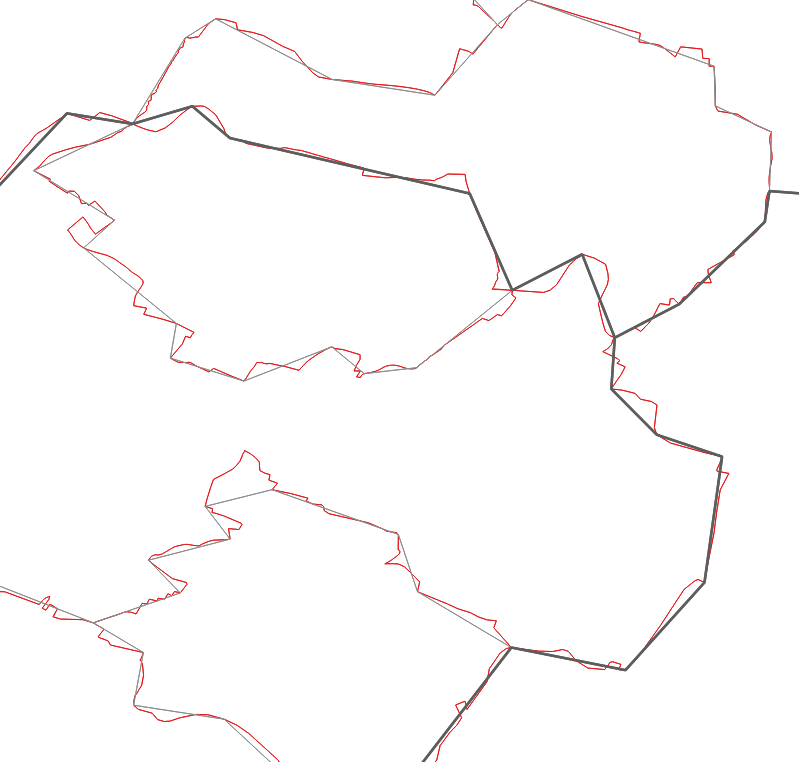
Using sf::st_simplify() in R or a similar command in QGIS on these shapefiles would create holes or overlapping polygons, shapefiles not being topologically aware. We could probably convert to lines, build topology, simplify, clean, build polygons in GRASS or ArcGis, but it’s quite a hassle…
A nice solution is using Mapshaper on mapshaper.org, or better for reproducibility using {mapshaper} in R. For such large dataset it is advised to use a node.js install instead of relying on the package’s embedded version.
On Debian-like :
sudo apt-get install nodejs npm
or on windows : install https://nodejs.org/. If needed add C:\Users\xxxxxxxx\AppData\Roaming\npm to your $PATH.
npm config set proxy "http://login:password\@proxy:8080" \# if necessary
npm install -g mapshaper
For ms_simplify() we will set sys = TRUE to take advantage of the node.js executable. Experiment with the other parameters to get a resolution that suits you. Here we use Visvalingam at 3%, squeezing the commune layer from 400 MB to 30 MB. From here we rebuild departement, region and epci with ms_dissolve() commands. Then we join back with original attributes and export in a geopackage with some metadata.
Télécharger le géopackage (communes, EPCI, départements, régions simplifiés, 2021-05) en WGS84 (EPSG:4326) – 22 Mo